Subsurface utility engineering
The data sheet, drawn on the real site.
Xtreme FieldNotes turns the paper excavation point data sheet into an app. Fill in the form, lock a satellite map of the test hole, mark up utilities with Apple Pencil, dimension from the map's own scale, and send a PDF before the crew leaves the site.
Walkthrough
One test hole, start to finish
Follow one excavation point from a blank sheet to a finished PDF. The narration is on screen, so it plays fine with the sound off.
2 min 22 s. The map in this video uses demo imagery; the app shows live satellite imagery.
How it works
From blank sheet to PDF in five steps
Each excavation point gets its own sheet. Everything you enter saves on the device as you go.
-
STEP 01
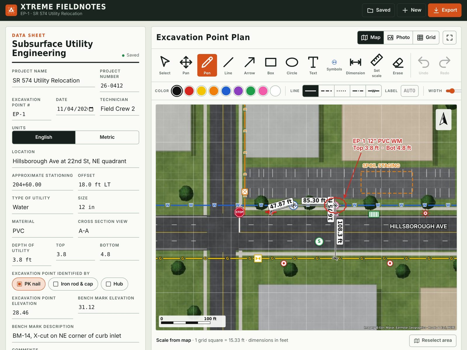
Fill in the data sheet
Every field from the paper form is here, in the same order: project, excavation point, stationing and offset, utility type, size and material, depths, elevations and benchmark.
- Type, or write with Apple Pencil and it converts to text
- Pick lists for common utilities and materials
- New sheets carry the project and benchmark forward
The data sheet and the plan side by side on a tablet. -
STEP 02
Find the site and lock it
Search an address or coordinates, or tap to center on your GPS position. Pan, pinch and twist until the test hole is framed, then lock the area.
- Satellite, hybrid and street layers
- Locking sets the scale bar and north arrow for you
- No signal? Use a site photo or the blank grid instead
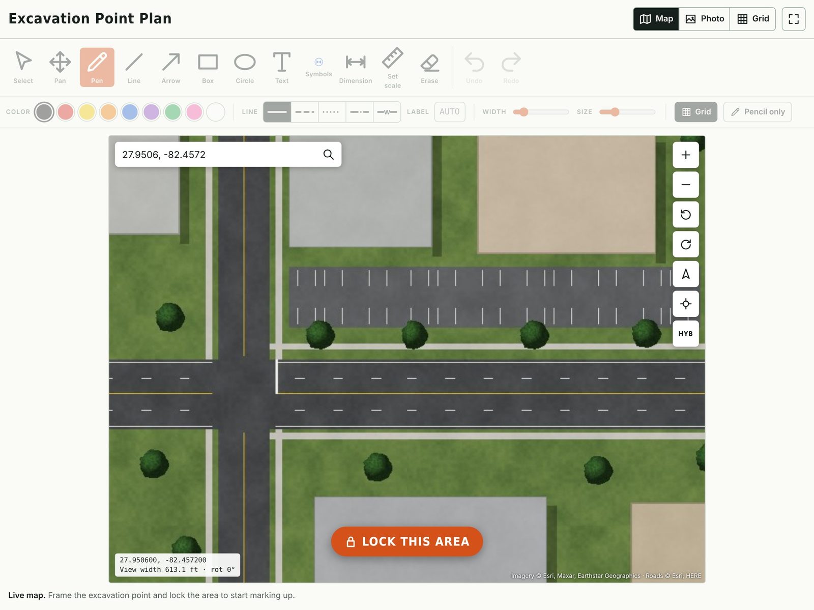
Framing the intersection before locking it. -
STEP 03
Mark up field conditions
Draw on the locked map with Apple Pencil, a stylus or a finger. Fingers pan and zoom while the pencil draws, so you never mark the sheet by accident.
- APWA uniform color code for every utility
- Solid, dashed, dotted, dash-dot and lettered utility lines
- Freehand, lines, arrows, boxes, circles and text notes
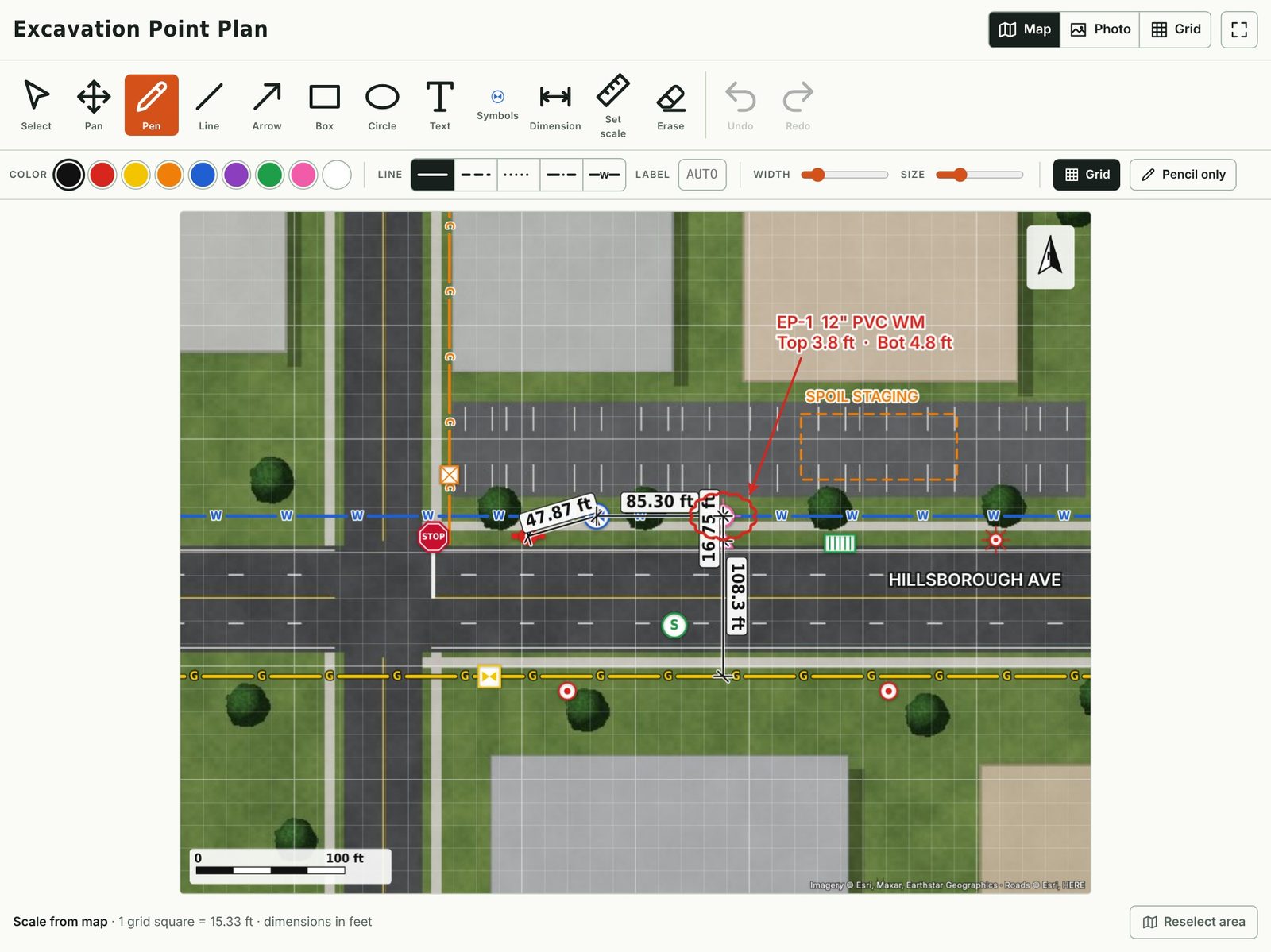
Water, gas and communication lines with a callout for EP-1. -
STEP 04
Place symbols and dimension
Drop in valves, hydrants, manholes, poles, signs and survey marks from the library. Then tap two points to dimension between them.
- More than 30 symbols you can move, rotate, resize and recolor
- Dimensions read in feet or meters and snap to symbols
- Calibrate any photo from one known distance
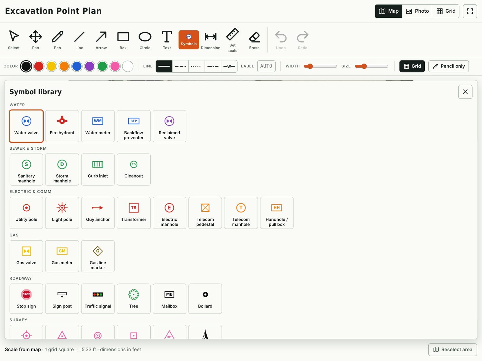
The symbol library, grouped the way crews think about a site. -
STEP 05
Save, back up and send
Export a letter-size PDF laid out like your paper form, a Google Earth file, or a map image that drops into AutoCAD at true scale. Share it by email, Teams, Drive or AirDrop. Every sheet stays on the device, searchable, until you delete it.
- PDF or image of the full sheet, ready to attach
- Google Earth (KMZ) with the plan, lines and symbols on the map
- Map image with a world file for AutoCAD and GIS
- One-file backup of every sheet, with restore on any device
- CSV export of the form data for spreadsheets
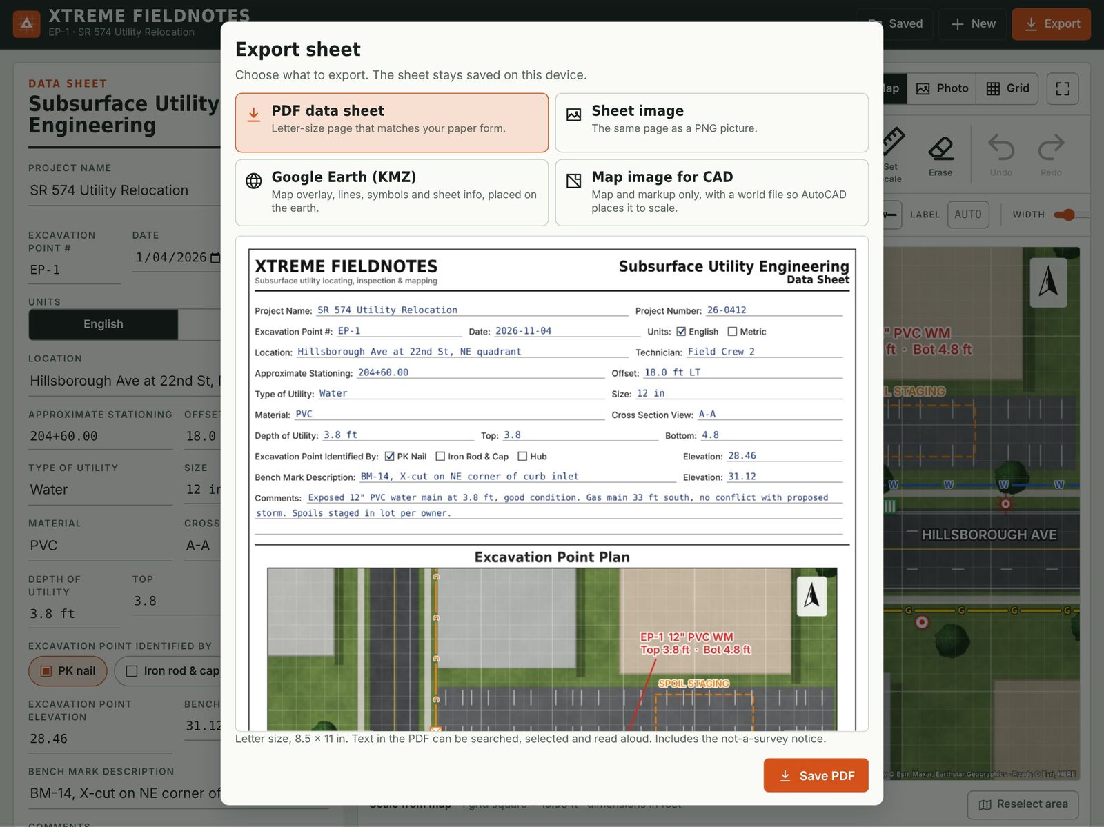
The export screen: PDF, sheet image, Google Earth or CAD.
Clearing a water main before the storm drain is designed
A designer needs to know where an existing 12-inch water main sits before laying out a new storm drain. A two-person SUE crew is sent to verify it with a test hole.
- Project
- SR 574 Utility Relocation
- Point
- EP-1, Sta 204+60.00, 18.0 ft LT
- Utility
- 12 in PVC water main
- Marked by
- PK nail
- Start the sheet
The crew opens yesterday's sheet and taps New. Project, number and benchmark carry over, so only the point details are left to fill in.
- Lock the site
They frame Hillsborough Ave at 22nd St on the satellite map and lock it. The scale bar and north arrow are set from the map.
- Record the exposure
The vac truck exposes the main at 3.8 ft. They enter depth, size and material, check PK nail, and add the elevations.
- Mark up the plan
Water and gas go in as lettered APWA lines. They place the test hole, hydrant and valve and dimension 85.30 ft from the valve to the test hole.
- Send it from the truck
They export the PDF and email it to the designer, then tap New for EP-2.
The designer has a to-scale plan with measured offsets before the crew moves to the next point. No scanning, no redrawing at the office, and no guessing at handwriting.
Benefits
Why not just sketch it by hand?
A hand-drawn sheet records what the crew saw. Xtreme FieldNotes records it to scale, on the real site, and gets it to the people who need it the same morning.
| Task | Hand-drawn sheet | Field Survey Notes |
|---|---|---|
| Base plan | Sketched from memory, not to scale, north guessed. | Real satellite imagery, locked with a true scale bar and north arrow. |
| Measurements | Taped in the field and written next to a sketch that doesn't match them. | Tap two points for a distance computed from the map scale, in feet or meters. |
| Symbols and colors | One pen, homemade symbols, and a legend that changes from crew to crew. | A standard symbol library and the APWA uniform color code on every sheet. |
| Legibility | Hard to read after rain, mud or a long day. | Typed text, or Apple Pencil handwriting converted to text. |
| Corrections | Erase, cross out, or start the sheet over. | Undo, move, resize and recolor anything. |
| Repeated info | Project, number and benchmark rewritten on every sheet. | Carried over automatically when you start the next sheet. |
| Delivery | Carried to the office, scanned or photographed, then emailed. | A PDF sent from the site in one tap, plus Google Earth and CAD files. |
| Finding it later | A folder in a truck or a filing cabinet. | Searchable on the device, with one-file backup and CSV export. |
Features
Built for how crews actually work
Apple Pencil, start to finish
Write in form fields and it becomes text. Draw on the plan while fingers pan and zoom.
Lockable satellite map
Frame the site, lock it, and the scale bar and north arrow are set from the map itself.
APWA color code
Red electric, yellow gas, orange communication, blue water, purple reclaimed, green sewer, pink survey.
Lettered utility lines
W, G, E, C and S lines label themselves along their length, the way plans are drawn.
Symbol library
Valves, hydrants, meters, manholes, inlets, poles, pedestals, signs, signals, test holes and survey marks.
Two-tap dimensions
Distances snap to symbols and read in feet or meters. Calibrate photos from any known distance.
Map, photo or grid
Use the satellite map, a photo or screenshot, or a blank 1-foot grid when there's no signal.
Carry-over on New
The next sheet keeps the project, number, benchmark, units and map location. Everything else starts blank.
Saved and searchable
Every sheet saves as you work. Search by project, point, station or utility and reopen it any time.
Four ways to export
A PDF that matches your form, a sheet image, a Google Earth KMZ, or a map image with a world file for AutoCAD.
Backup and restore
Save every sheet, with its map and markup, to one file. Restore it on any device. Export a CSV too.
Works offline
The form, markup, saved sheets and PDF export all work with no signal. Your sheets stay on the device.
Phone and tablet
Every screen in the truck
The same app runs on iPhone, iPad and Android phones and tablets, in light or dark mode. Install it from the App Store or Google Play, or add it to the home screen from the browser.
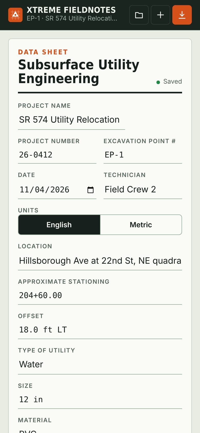
The form on a phone
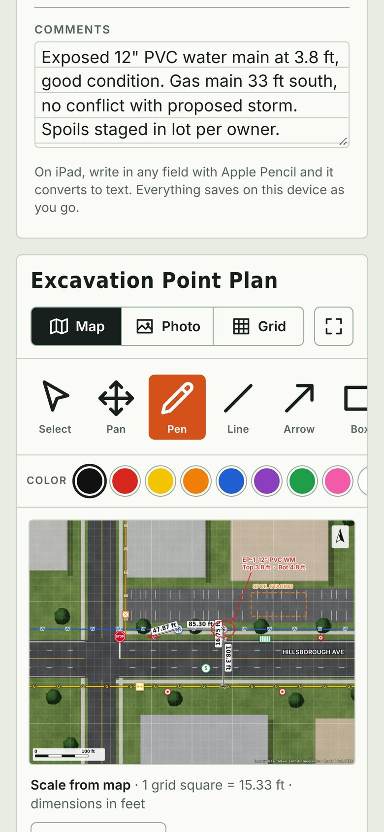
The plan on a phone
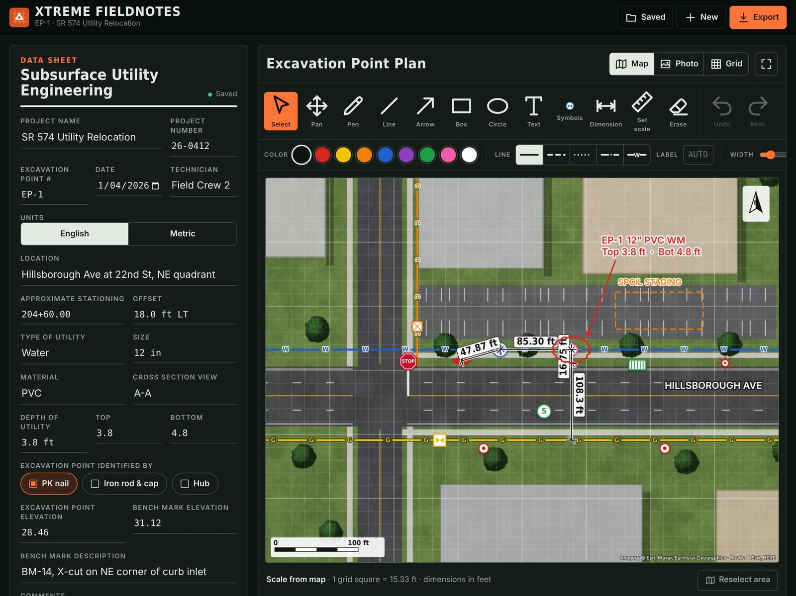
Dark mode on a tablet
Sample output
See a finished sheet
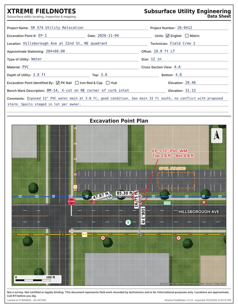
This is the EP-1 sheet from the walkthrough, exported exactly as the app produces it.
- Every data sheet field, with units and how the point is marked
- The locked plan with scale bar, north arrow and coordinates
- Lettered utility lines, symbols, dimensions and notes
Every exported sheet carries a notice that it is not a survey and is not certified or legally binding. Read the full disclaimer.
Get started
Put it in your crew's hands
Ask for a demo, pricing, or user accounts for your team, and we'll follow up with the details.